Axelspace Corporation (“Axelspace”), a leading developer and operator of microsatellites dedicated to realizing its vision of “Space within Your Reach,” announced that “AxelGlobe,” the Earth observation web platform service, has been continuously selected by the Geospatial Information Authority of Japan (GSI) to assist in improving the efficiency of national basemap updates by utilizing satellite data and AI technologies.
Background of the Continued Selection
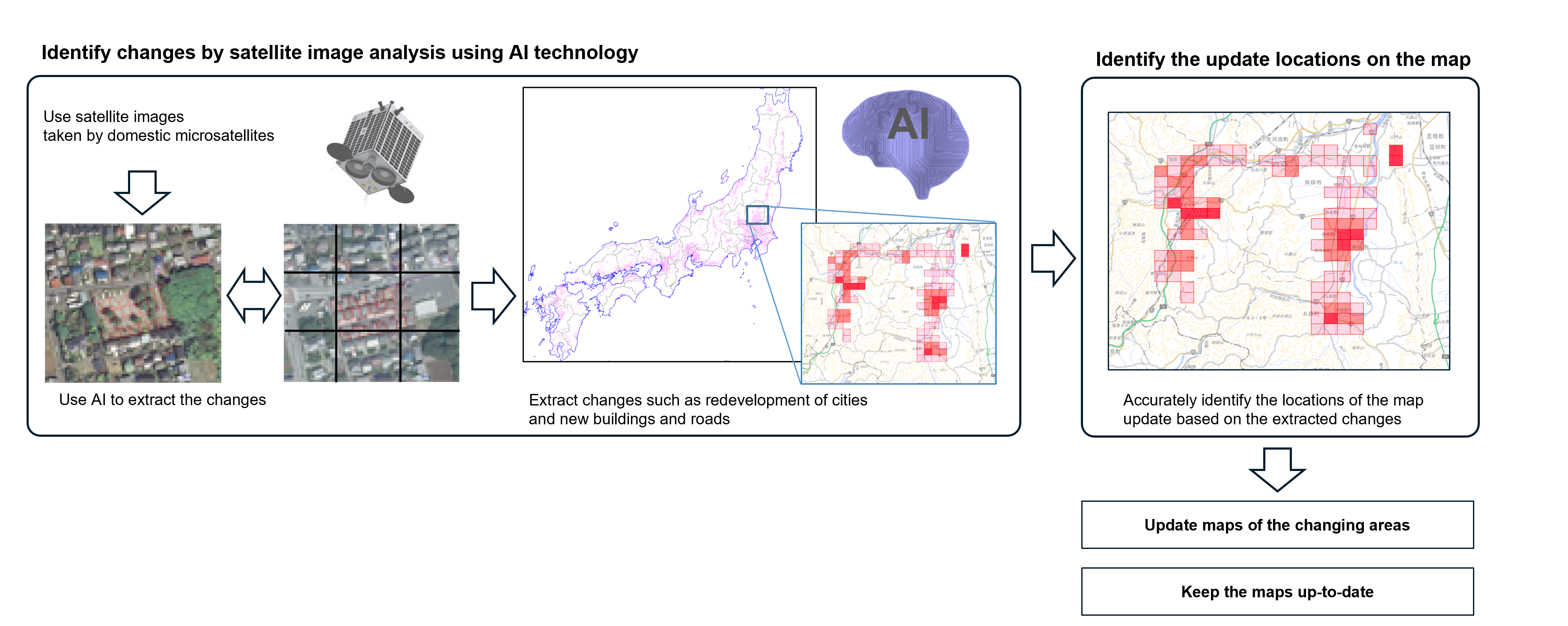
Since the initial contract in fiscal year 2023, Axelspace, the largest optical satellite constellation*1 operator in Japan, has contributed to the development and updating of the digital national basemap led by GSI by providing satellite imagery acquired by its five proprietary optical satellites “GRUS.”
The digital national basemap is a foundational digital map created by GSI to represent Japan’s land in a unified standard. It serves as the fundamental data for maps used across both the public and private sectors, supporting a wide range of applications such as car navigation systems, map applications, and hazard maps. As a result, the development of the basemap and its promotion are positioned as key government initiatives. To enhance the productivity of these activities, GSI has been advancing the development of technologies to extract changes from both satellite images captured at different times and AI-generated image analyses.
Axelspace’s Earth observation platform “AxelGlobe” enables repeat observations of the same locations on Earth every two to three days using five GRUS-1 satellites, which provide a spatial resolution of up to 2.5 meters. By leveraging the GRUS satellites’ high-precision attitude control capabilities, AxelGlobe delivers satellite imagery from around the world on a tasking basis, tailored to specific user requirements.
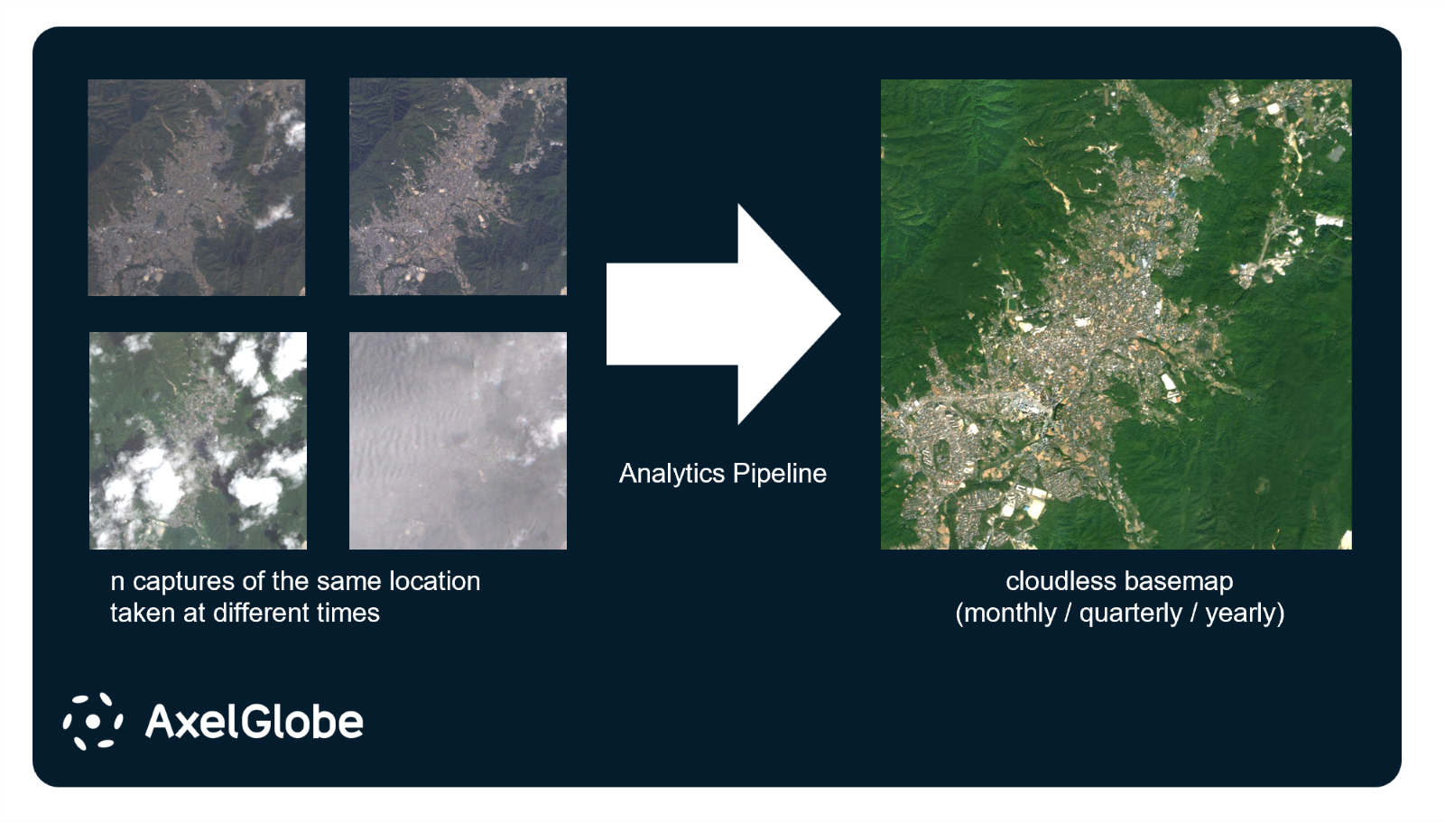
For this project, Axelspace has leveraged “AxelGlobe Mosaic,” a product developed in 2023, to generate and deliver cloud-free satellite imagery that reflects the latest conditions of geographic features*2 across Japan over multiple years. This has been achieved by compositing multiple images of the same locations captured at different times.
In particular, the ability of medium-resolution satellite imagery to efficiently cover wide areas has proven highly effective in operational workflows focused on change detection. Beyond providing raw imagery, Axelspace has supported geospatial data development by delivering processed, and quality-adjusted imagery for analysis and practical application.
Axelspace remains committed to supporting the development of national geospatial infrastructure and addressing societal challenges through the continued provision of satellite data.
note:
*1 A system in which multiple satellites operate in coordination as a single system.
*2 Information representing geographic features such as roads and buildings, as well as land conditions including vegetation, cliffs, rocks, and other structures.
About AxelGlobe
Official Service Website: https://www.axelglobe.com/en
About Axelspace
Guided by its vision—“Space within Your Reach”—Axelspace has been at the forefront of microsatellite innovation since its founding in 2008. Leveraging cutting-edge expertise in microsatellite design, manufacturing, and on-orbit operations, the company is redefining how people and industries access space. Its flagship businesses, AxelLiner, which provides satellite development and operation services to help customers realize their space missions, and AxelGlobe, which delivers Earth observation data through Axelspace’s proprietary optical satellite constellation, are driving a new era of space utilization. Through these initiatives, Axelspace is shaping a future where space is accessible and within reach for everyone.
Axelspace Corporation
Headquarters: Tokyo, Japan
President and CEO: Yuya Nakamura
Founded: August 2008
https://www.axelspace.com/
Contact Information for Media
-
Axelspace Holdings Corporation
E-mail:pr@axelspace.com